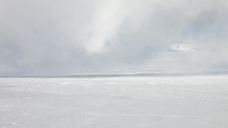
#16
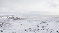
FLYING FALLS
HD video, 23', loop, 2012
9 sequences on the sublime and frail nature of the Icelandic landscape
Through seemingly endless steady shots, the camera grasps pure nature in constant change alongside man-made traces of energy depletion.
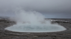
Image Context
Deep Drilling Project IDDP-1, digging site at Krafla, Mývatn
Krafla is a volcanic system spanning approximately 100km in length in the north of Iceland. It is located between Leirhnjúkur and the Víti crater in the central part of the active geothermal area. To obtain energy and valued chemicals from this high pressure hydrothermal system, a well was proposed which would reach a depth of 4500m. Drilling commenced in 2008, however, in 2009 at approximately 2100m, magma was struck. The consortium of companies consisting of Landsvirkjun, Orkuveita Reykjavíkur, HS Orka, Orkustofnun, Alcoa and Statoil had to halt further progress. The current exhaust steam from the hottest drill hole in the world has a temperature of 330°C and produces pressures of 140 bar.
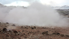
Gunnuhver and geothermal power plant Suðurnes
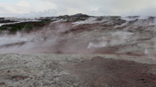
Gunnuhver is a high temperature area on the Reykjanes peninsula. The temperatures underneath these wells are over 300°C. This volcano emerged in 1967 from an earthquake and the resulting shift in the earth’s crust. The energy from this volcanic system is used in the Suðurnes geothermal plant. Due to the drillings made at the geothermal power plant the activity of the fumaroles (volcanic steam openings) has risen enormously. The volcano has become more active since 2006 after an explosion in the well that made the area non-accessible.
Jökulsá á Brú
Originally Iceland’s "dirtiest river", this glacier river in the east of Iceland once transported 120 tonnes of rocks and detritus in the delta area towards the North Atlantic within an hour. Today 25 km of the original length of 150km are being led into the Hálslón dam lake of the Kárahnjúkar dam and instead arriving in the ocean through the river Lagarfljót. The dam lake feeds the power plant Fljótsdal that produces the energy for the aluminium smelter for the US company Alcoa in Reydafjördur. The water volume has been reduced from the initial 205m3/s to the present-day 95m3/s. Normally in summer, the melted glacial water from the highlands continually feeds the glacier rivers throughout the season. However, more recently, the Jökulsá á Brú gets a flash flood only once in September – when the spillover from the dam lake has to be drawn off leading to floods along the river shores.
Waterfalls
There are small waterfalls near the big Seljalandsfoss in the south of Iceland, located directly along the ring road between Hvolsvöllur and Skógar.
The Great Geysir
The Great Geysir is the oldest and still partially active geyser in Iceland. The geothermal field in Biskupstungur and the Great Geysir are more than 8000 years old. Its name is derived from the Icelandic word gjósa (sputter), and it is the term for all geysers of this kind. The first eruption was recorded in 1630. Its sputters occur in regular and irregular intervals, in various heights, up to 60m. With the tectonic movements in the bedrock some conductive pathways are becoming blocked through and the heated ground water cannot pass through. In the event of an earthquake this ground water unloads. The geyser awakened in 1896 by a strong earthquake and again and sputtered once or twice daily to its original heights. In 1916 the geyser stopped all of its activity. Only by digging a drain to reduce the water plane could the geyser be awakened due to the buildup of pressure. Icelanders began to use soap to initiate the geyser to erupt where it is estimated that 40kg of soap was added to the geyser, turning it officially into a laundry. In 1992, environmentalists deemed the geyser to be a protected conservation area and for eight years it was inactive. In June, 2000, the strongest earthquake since 1912 hit the south of Iceland and 4 days after a 40m high water fountain came out of geyser’s pool. It was flagged again and in 2008 during the next earthquake it spurted 2-3 times daily. Currently, it only bubbles up and fizzles slightly. The soluted minerals from the heated water form a big cone with sinter terraces around the well.
Húsey
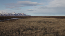
Húsey is located 60km north of Egilsstadir in the area of Hérasflói. It is between two glacier rivers, the Jökulsá á Brú and the LagarfIjót, that both lead into the ocean. Húsey is only slightly above sea level in the estuary delta. The construction of the Kahranjukar dam, 120km away in the highlands has far-reaching consequences for the lowlands because of the congestion of the two rivers. As a result of increased erosion of the land and changes in the coastline, the flooding of the arduously revegetated sand areas, a decrease in the seal population in the bay, and lack of food for the entire species-rich animal life, the river is no longer used for transport for the local population.
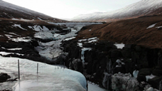
Dyrfjöll and Lagarfljót
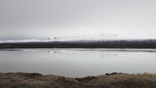
Dyrfjöll (1136m) is a mountain range west of Borgarfjörur and east of the community of Fljótsdalshérad. Its name is derived from the gain Dyr, 856m, that is formed like a door. Its ground is glaciated on top. This mountain range is one of the oldest parts of Iceland and was formed 12 million years ago, due to its proximity to the Hot Spot. It is said that the queen of elves, Borghildur, lives there. Even in heights above 1100m, a remarkable 17 flower species can be found. As a result of the Kahranjukar dam the water of the Jökulsa á Brú is being led to the slower running Jökulsa á Dal which leads to Iceland’s largest lake, the Lagarfljót. This formerly calm and blue-silverish shimmering lake, a tourist attraction, has turned muddy, dirty and grey. Sunlight does not reach the original depths and therefore photosynthesis is now constricted, meaning less food for the fish. Measurements concluded a change in light from 60cm to a mere 17cm today. Fish species have become fewer in numbers and smaller in size. The residents are confronted with massive soil erosion because of the rising water masses and potency.
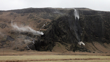
Seltún
There is a solfaratas field in the active volcanic system Krýsuvík on the Reykjanes peninsula in Iceland. Solfataras are 100-250°C hot post-volcanic exhaltations of gases that mainly contain hydrogen sulfide (H2S), carbon dioxid (C02) and water vapour. In the middle of the 20th century there were plans to use the geothermal field for energy production and Séltun became one of the main drilling sites. One bore hole was drilled in the 1990s and supplied the city of Hafnarfjörur with energy. In 1999 the site exploded and since then the geothermal area was no longer used, depressing the economy. One bore hole breaks out intermittently since 2010. The exploded hole in 1999 formed a crater of 30m in diameter that is now filled with mud and steam is arising from it. Since the earthquake in June 2000, the heaviest quake in the south since 1912, Seltún is quieter than before, and the biggest boiling pot is not active anymore. Seltún has changed greatly during the most recent years. The geothermal activity has clearly increased, there is more steam with a higher pressure ascenting and the water level of the lake has risen. Presently, after a series of earthquakes there are media reports that the activity on the geothermal fields have also increased. Geologists hypothesize a connection to a new volcanic eruption.
Hveragerði
Hveragerði is a community in the south of Iceland, approximately 40km east of Reykjavík with 2315 inhabitants. It is Iceland’s only town with a field of hot springs amidst the rural landscape. It consists of 4 bore holes, approximately 300m deep that convey 180°C warm water used as geothermal energy. In the garden of hot springs(translation of the city’s name: Hveragerði) there are numerous green houses in which plants, flowers, fruit and vegetables are cultivated. Remarkably in some they even grow bananas, cacti, oranges, figs, and other warm weather plant species. The power is supplied by overhead contact wires crossing the landscape from the nearby Hellisheidi power plant, the newest of the 5 geothermal plants in Iceland. The drainage of the geothermal water is still quite complicated. The biggest problem is the precipitate of Silica that block the bore holes and pipes. If a bore hole is dug there can be cracks and fractions. The water pressure that is being put back into the hole can boost these breaking points and cause more earthquakes. Experiments to return that byproduct of geothermal energy back into the soil where it came from are being undertaken. Consequently, these experiments have already led to earthquakes in the nearby Hveragerði.